
SWITCH FIELD. The diagram below is the existing street plan of the Fifth Ward. Directly below it is a translation of that plan into a "point field" of street intersections. Like nodes in any network, intersections establish the connectedness of a larger urban field. Tracking those intersections is not only a way of determining if one may procede left, right or straight ahead (or whether one may proceded at all), it is also a way of tracking the relative spatial "continuity" of any given street network.
With regards to mapping this spatial continuity, the very first observation is that the intersections in a street network are not equal to each other. Each point has a different “status” as regards to its ability to connect to adjacent nodes. The status of each point can be determined for the present configuration of each intersection whereby a four-way switch is an intersection that is open in all four directions. A three-way switch is a T intersection. A two-way switch is a simple bend in the road, and a one-way switch represents a terminal node. The final switch is a “null” point where the intersection was completely demolished or never built in the first place. With regard to these five states, the term “switch” reflects a varying status. A switch suggests that actual street intersections are not only variable but that their status can be flipped or otherwise altered at will. Moving directly from analysis to design, the switch field becomes a tool for the active manipulation of urban continuities based on the relative status of a given intersection. In other words, the switch field made a spatially biased reform of urban infrastructure possible. It also delivered the specific means of intervention.
The Switch field is the basis for the entire Fifth Ward project. The status of intersections measured in terms of relative continuity and discontinuity are, at one level, a simple diagram of physical access. On an entirely other level, however, dis/continuity of intersections is an indicator of the dis/continuity of space. In this regard, dead-end cul-de-sac streets are not automatically “bad,” and open (four-way) intersections are not automatically “good.” Such prejudices operate off of outmoded urban assumptions and ultimately limit the number of viable options. In the context of the switch field, the so-called dead-end street becomes an important device used in the production of spatial continuity. Considered as a switching mechanism functioning within an overall urban network, the dead-end is redefined by its capacity to mark the end of form and the beginning of space. The capacity to quantify and manipulate space is the single most important factor in the design of Megalopolis — an urbanism that is, first and foremost, dominated by space.
 |
| FIFTH WARD EXISTING STREET GRID |
 |
| EXISTING WARD INTERSECTIONS EXPRESSED AS A POINT FIELD |
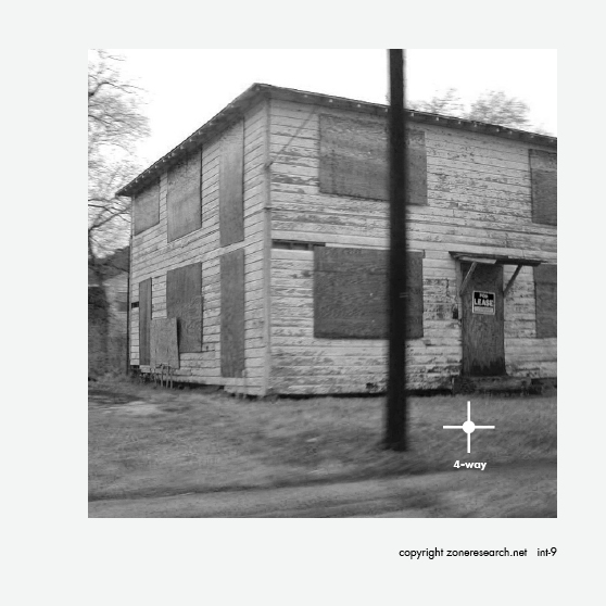
FOUR INTERSECTION TYPES. Below are a series of images of the Fifth Ward that are marked in relation to their adjacent intersection or switch. Top Left is a large warehouse that sits at the end of a cul-de-sac or one-way intersection. To the right of that is an image of "elbow" or two-way intersection that blocks of the street grid from the freeway and the Houston CBD seen beyond. Lower left is a "T" or three-way intersection where a misalignment creates a subtle form of barrier to the continuity of the gridiron. The fourth is a an abandoned duplex sitting in the middle of a residential area surrounded by four-way intersections. Residential areas exhibit a greater continuity of street infrastructure than any other program area.


CHARACTERISTIC INTERSECTIONS. The two diagrams below mark the location of the three-way intersections (left) and the location of the four way intersections (right). The three-way intersections form a network of invisible "walls" that run throughout the Ward. The four-way intersections typically indicate residential fabric, in this case, a field of single family houses.


THE FIFTH WARD BY INTERSECTION. The spatial characteristics of a residential neighborhood are bound up in the state of the network in which they sit. The images of the Fifth Ward above and below are marked by their adjacent intersections which divulges as much information about the actual location as does the image itself. Specifically, the overriding spatial characteristics of a dead-end street or a completely open four-way intersection hardly register in visual documentation. We know what the end of the road feels like as surely as we know what it means to be presented with four viable directions of travel. The status of the intersection is perhaps more valuable as an existential indicator than a "realistic" visual portrayal.


NULL FIELD. Below is the diagram of all the demolished or unbuilt intersections of the Fifth Ward. For all the tragic mistakes of urban construction, there is no greater tragedy than that which was never built in the first place. The unrealized continuities of these unrealized intersections make an abstract testament of lost potential that reverberates across the city. Nowhere is this reverberation felt so strongly as in the mile upon mile of cul-de-sac subdivision that constitute the majority of Houston's urban fabric. "Let me feel the lack..."

return to project thread

No comments:
Post a Comment